Showing posts with label nature photography. Show all posts

Old Estates being Put to Good Public Use

There are many old estates on Long Island that were given or bought by the state of New York Parks Department. They are beautiful reminders of the bygone age of decadence and extreme wealth by a handful of tycoons in turn of the century. As the country grew and the Internal Revenue Service was formed to pay for services, the enormous tax bills forced many of these properties to be sold off or given away.


Luckily some forward thinking individual in private and government employment thought to preserve our history and land for the future, The history of such places such as the Vanderbilt Museum on one of the old Vanderbilt properties on the north shore of Nassau County, New York, the Southside Hunting Lodge, now the Connetquot River State Park on the south shore of Suffolk County and  Belmont Lake State Park, established in 1926;formally known as "Nursery Stud Farm", a thoroughbred horse farm owned by August Belmont, according to Wikipedia.


The Belmont Lake State Park sits on the Southern State Parkway in Babylon, New York. It is very well used ,with a large main lake, and a walking trail that heads south to two more lake that are not officially park of the park. I have been to this park many times and it never disappoints.


Belmont Lake Dam

 The Belmont lake dam is
small but useful as it created
a large lake enjoyed by fishermen and small paddle boats alike.


The weekends are popular for large hiking groups to visit.

Belmont Lake Trail


a captured cannon sits on the estates lawn


The  walkers enter a tunnel under the parkway and further south , there is another tunnel that runs under a highway.
The trails run along the Carlls River
 
 
It was becoming cloudy so the last 2 images aren't very clear, but this is another large body of water called Southards Pond that is connected to the trails that runs from Belmont Lake State park.
 
 
Southards Pond is a favorite of fishermen.


Hidden Histories of a Nature Walk

One wouldn't think of a  suburb of New York City, as having an country look or feel to it. The parks and preserves of Long Island are a treasure for all to enjoy. A few wise groups have fought the developers and government to preserve vestiges of the past for the future generations to learn from.

The old Long Island was once home to many estates of millionaires, especially on the coastal shores.
As time went, the masses from the cities moved out to the rural countryside of the island and may have worked for one of these estates.  This was once the Southside Sportsmen Club
Here is a video to explain.


https://www.youtube.com/watch?v=w1mB-X5qgCE

Westlbrook lake looking north to the highway.

I have hiked and photographed Connetquot State Park in the autumn  but this time the park was more colorful before summer.


I grew up in this area and knew this to be a dairy farm. I'm glad it wasn't developed.


The group I traveled with started out in the Westbrook lake south of sunrise highway.


We came upon high grasses, large growth trees and wonderful lake views.This tree was so wide I couldn't capture all of it.


We walked along a dirt path that brought us to a catwalk under the highway and into the park on the north side.

A stop along the lake once inside the park. This was a great fishing location.


A nice, shady spot to rest along the way. Someone made some benches for the weary.


An old  lodge building overlooking one part of the lake inside the park.


And horse riders are welcome here. there is no stable so you must trailer your horse or ride them in from one of the side entrances if you live around the park.
No bikes are allowed so far.
horses are welcome


The fish hatchery is a vital part of this park and welcomes many anglers.


 I took a last shot of the lodge and mill house across the lake with the swans diving for food before leaving. I think this is a great oasis in a crowded suburbia  that we live in today. 
If you would like to help preserve this beautiful park, then join the Friends of Connetquot soon. www.friendsofconnetquot.org/

An Autumn Trip to Koger Arch

Yamacraw Bridge in summer.
I recently went on a trip to the southern region of Kentucky, close to the Tennessee border. I  have made trips to the area in the past but had a new mission in mind.
McCreary county, off of hwy 27 has very remote, isolated areas that are part of the Daniel Boone National Park. There are very curvy roads, cliffs, overhangs with rock slides and steep drops into valleys.


Koger Arch Sign
My friend and I decided to check out an arch that we visited a few years ago. This time the weather is more conducive for hiking. The last time it was in the middle of the summer when we made the trek and the bugs and heat were too much.


Leaf covered trail


The Koger Arch area is  dotted with many lesser known arches and not as accessible. The best know one is Natural Arch just north  off  hwy  700. This is also in the Stearns  District of   the Forest.

stone steps


Koger Arch now has a new sign on the side of the road so it was a little easier to find. I applaud the volunteers who clear these trails and made steps and directions to these locations. The Sheltowee Trace Hiking group, along with the forest service, maintain the trails and nail in markers on the trees to help hikers find their way. Their symbol is a turtle.

We drove south of Somerset, on hwy 27, past the Natural Arch, until we reached 92 on the right and followed that until Yamacraw bridge. Make a left onto hwy 1363;drive until you see Rock Creek Rd that becomes Wilson Ridge Rd. You should see the new sign on the left side of the road.


Beneath Koger Arch


The arch is larger than I remember, certainly an impressive sight. The leaf covered trail is a little slippery in the fall, so use the walking stick for balance. I couldn't see the steps until we got closer to the arch itself.


All in all I was not disappointed and love to walk in the wilderness. Be careful traveling in these isolated areas. There is no one around if you fall and be hurt. Always bring a friend or two, and of course, your camera. I used my new Sigma wide lens and love the effect.


Koger Arch

An Afternoon at the Lake

Green River Lake State Park in Taylor County, KY is a lovely lake that was created by a dam built by the Army Corp of Engineers. Like most of the man-made lakes, it is also maintained by the Army Corp.

There are marinas, campsites and wilderness trails surrounding it.

I recently ventured in the park after living nearby for 8 years. I don't know why it took so long to check it out but I'm glad I did.

It isn't very primitive like most of the parks I've visited,  but it's worth the trip since it is so close.

Going in the autumn and winter allows me to wander and shoot nature undisturbed.


The first trail my friend and I entered was the Beaver Pond and Salisman Trail. This is the first one on the left after crossing the dam. The trail is almost invisible due to leaves covering it and so we didn't stay long but did find another visitor along the way.


The Eastern Box turtle crossed the path, searching for mushrooms. He or she let me photo graph them so may be he or she were used to visitors.


We drove to another picnic area which was
 surrounded by beautiful colors of autumn leaves.


My friend is posing on the fence. Notice the blue lake in the background.


The beach is closed but the warm November day was so inviting.


Boaters enjoyed the open water I'm sure.
The brown and red background are a wonderful contrast to the blue lake.


The southern part of the lake at the end of lakeside trail shows an open span of water.

My friend was brave enough to sit on the edge...I wasn't !

It's such a peaceful place to relax for the afternoon and just think.

I


We climbed back up the hill to the car and bid a fond farewell.  I will return and snap more photos I'm sure.


Sometimes we need to check out the local

A Big Surprise at Yahoo Falls


The morning clouds left me annoyed, thinking that it would turn out to be another dark cold day like the previous one.

But by 11am, breaks of sun popped through and my mood immediately lightened.
Yay! I'm going out to visit one of my favorite locations to photograph nature; Yahoo Falls.

It turned out to be a beautiful Sunday afternoon . The temperatures had risen to the low sixties; all the way up from a morning low of 49 degrees!

I have been to Yahoo Falls at least 4 times in almost every season. It is located in the upper part of the Big South Fork National  River and Recreation area that extends into Alardt, TN.  Daniel Boone Forest and Big South Fork are connected and it's hard to tell where one area stops and another begins except for the signs.


Yahoo Falls is easy to find. If you drive north from Tennessee, on highway 27, you will turn left onto highway 700, in Whitley City, KY.
If traveling south on highway 27, just turn right on highway 700.
Follow this narrow, winding road, slowly and you will reach the signs about a few miles due west.


I bought along a friend who had never seen this before so it was a treat.
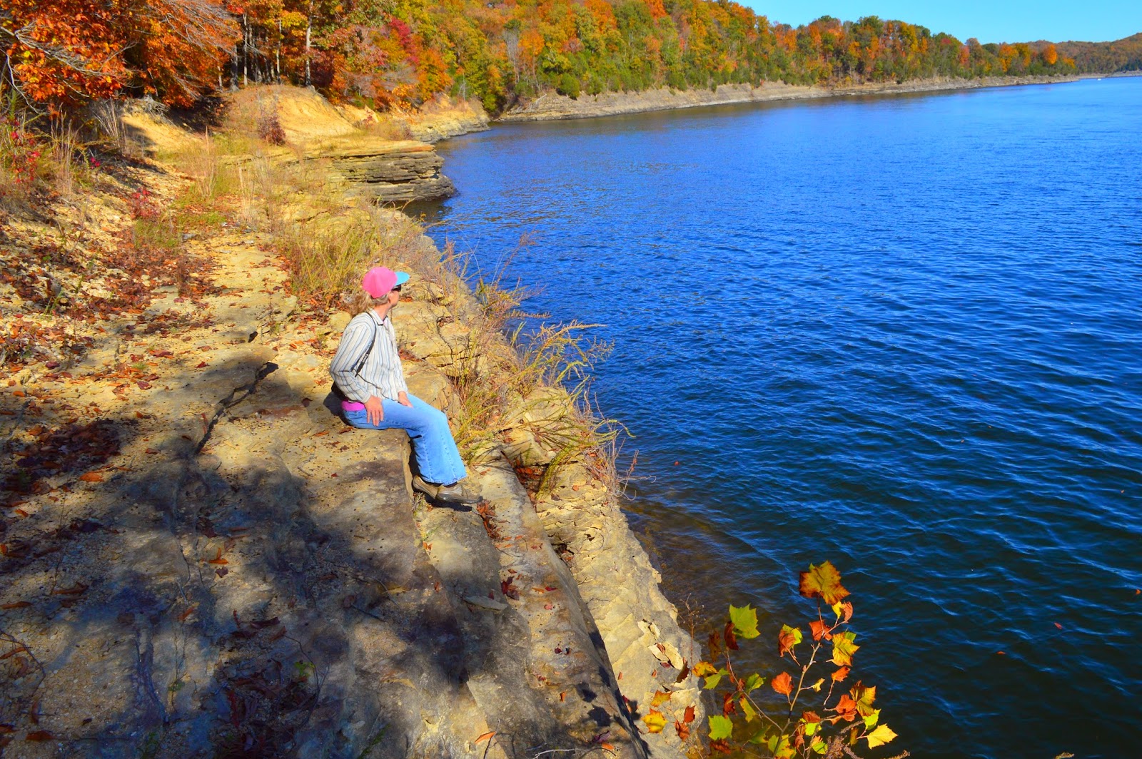
There is an overlook near the parking lot and the water is always green. The fall colors are just changing and I didn't want to miss them. There are about three overlooks along the way to the falls.
I discovered that the falls does not enter or come from the river at all. it comes from a small creek on top of a ridge, and hikers can cross over and stand over the falls.

There are several ways to get down to the falls, so we picked the red, metal, steep, stairs. This is fine going down but not going up!


The recent rains made a decent amount of water for the fall to be photographed. There were other visitors around so maneuvering to get a good shot proved a challenge this day.


Due to the shade I had to raise the cameras ISO to 1600 and 3200 so there was some graininess, when magnified.

Photographers love to get clear crisp shots but nature doesn't always provide the best lighting.


The Yahoo Arch was next on the agenda so off we went.
The trail seemed a little longer than a year ago. It ascended steep hills and turned many times. I was a little breathless at some points and had to rest. I guess I am getting old or need more practice.


At last we found the arch. Actually it seems to be a rock house an arch and a cave with a hole on top. It never disappoints, at any case.


After snapping photos for 30 minutes, we decided to go back. There is another arch named marker arch further up the ridge about a 1.6 miles but it was getting late.

We walked back through the heavy woods and we stayed on the upper path this time. It was shorter.
As we came to the top of the falls, my friend decided to venture on top; I wasn't as brave.

I have wondered through the woods of Daniel Boone National Forest and the Great South Fork National Recreational and River Area for a few years now and never encountered any wildlife larger than a squirrel or rabbit. Black bear alerts were posted on most trails so I kept an eye out for them.

Then as we left the park road and drove down the road a little when something caught my eye. A very dark image appeared next to the road. I drove slowly up to this and saw the eyes and realized it was a black bear! My first encounter after all the trips and hikes. I was so amazed, scared and delighted at the same time!

My friend had the vantage point and managed to get a few shots before I could get my camera out of its bag. The young bear quickly walked away as he realized we were not there to feed him.

So here's my first bear sighting. I am so glad we didn't meet up with this on foot!
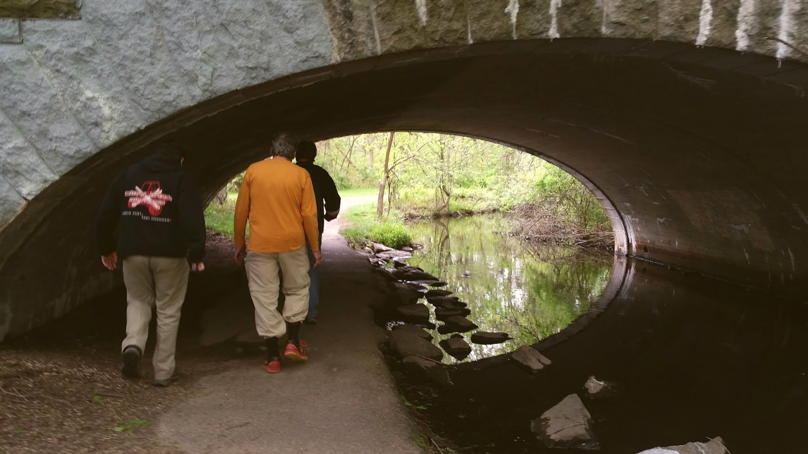


The Best Little Park known as 76 Falls ,KY

There's a sweet little park with such a beautiful waterfall, and not many know about it.
Just a small roadside parking area leads visitors down the steps, across a cascading creek and into a small picnic area.

One can walk right next to the top of the falls(behind a fence) and see the water rolling over limestone creek bed and down about 83 feet.


If you walk to the left of the falls and around the fence, you can get a side view glimpse of this beauty.  I'm not advising anyone to do this and especially if small children are present. There are wooden crosses around the fence line reminding all that others got too close to the edge.


Another view of the 76 falls is on the overlook, which is back over the wooden bridge and to the left this time (or right if approaching from the parking lot.) There is a steep set of steps taking you up to the overlook which gives the best views. I sat on top of the stone wall for this shot.


Since you won't find any signs anywhere,
the best way to locate this is to approach it from hwy 90 in Albany, KY,  and  turning onto hwy 734 and then right onto hwy 3063.
Follow that a few miles and you'll see a small parking area on the left.
But most people who visit the falls, come by boat and find it in a cove called Indian Creek, left of Grider Marina.

There is a nice website to read about a town that existed there one time called 76 Falls. It was wiped out by a killer tornado and never recovered.

Colditz Cove State Natural Area -A Small Park with Lots of Appeal

Northrup Falls is located in Colditz Cove State Natural Area in Allardt TN. by driving hwy 127 north or south.
Day-trippers can find it on 
old hwy 52 and follow the signs off the hwy to county road 1636. It is just before the historic own of Rugby, traveling east.

This is an unassuming wooded park that would easily be missed if you didn't pay attention.
Walking down the leaf covered path to the wonderful waterfall is an easy hike but be sure to take along your camera. The scenery is beautiful.


The Northrup waterfall is not only the best part; walking beyond it will treat hikers and photographers to interesting features.

If you like to see natural paths, rock formations, caves, pine trees, flowering shrubs and animals, then this is worth the trip.


This one cave overhang that can make some feel very small. There are large, jagged rocks and boulders on the ground that you may have to navigate over.

I'm always looking up for something to drop; maybe I'm a little paranoid that way.


A typical stone walkway over a small stream is a challenge when wet. Keep your camera in a padded bag and use your walking stick to keep your balance.
So go for just the waterfall or explore the park for a few hours. Its a fun way to spend the day and get some exercise.